
The Wider Chronicle | October 22, 2026
Somalia’s federal government has condemned a map displayed during a security briefing by Israeli Prime Minister Benjamin Netanyahu, saying it misrepresents the country’s borders. The map placed Somaliland and Puntland in a different geopolitical grouping from the rest of Somalia. Mogadishu’s response, issued on Wednesday, reaffirmed its position that both remain part of Somali territory.
In its statement, the Ministry of Information, Culture and Tourism described the map as misleading and urged international partners to respect Somalia’s sovereignty. It cited the Somali Constitution, the United Nations Charter and the African Union’s founding principles. The government said foreign officials and organisations should not present Somali territory in ways that undermine the country’s unity.
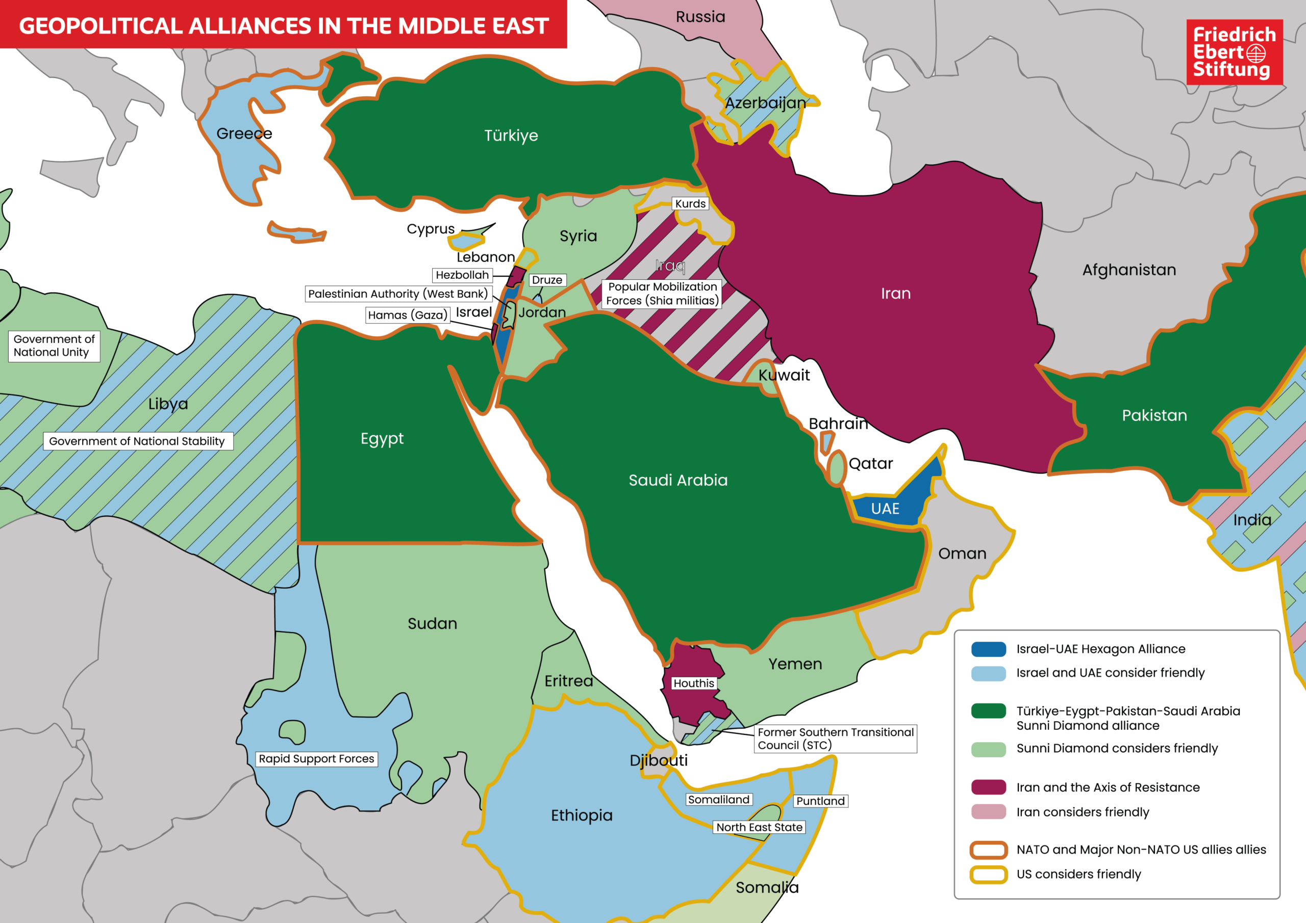
The map appeared during Netanyahu’s October 18 security presentation. According to Somalia Today, the graphic matched a map published in May by the German political foundation Friedrich-Ebert-Stiftung and credited to Marc Saxer and Marcus Schneider. Its colours grouped Somaliland and Puntland among territories the authors assessed as friendly toward Israel and the United Arab Emirates. Other parts of Somalia appeared in a separate category associated with Türkiye, Egypt, Saudi Arabia and Pakistan.
That distinction matters when interpreting the image. A map describing perceived political alignments does not, by itself, establish a formal alliance or announce recognition of a new state. Somalia Today noted that the graphic was not evidence of Israeli recognition of Puntland, which remains a federal member state of Somalia. Its appearance behind Netanyahu nevertheless gave the map a prominence far beyond an ordinary research publication.
Somaliland and Puntland also have different political positions. Somaliland declared independence in 1991 and continues to seek wider recognition, while Puntland operates within Somalia’s federal framework. Israel had already recognised Somaliland before this latest dispute, a decision strongly opposed by Mogadishu. Treating the two as interchangeable would obscure an important part of the story.
For Somalia’s government, the objection concerns how the country is represented on an international stage. For readers, the central question is what the presentation actually signals about Israeli policy. The reporting establishes that the map was displayed and that Mogadishu rejected it; it does not establish that the image announced a new agreement with Puntland or settled any disputed boundaries.
Reporting sources: Dawan Africa; Somalia Today; Reuters. Map: Marc Saxer and Marcus Schneider / Friedrich-Ebert-Stiftung, May 2026. The map depicts its authors’ assessment of political alignments, not internationally agreed borders.